
No added infrastructure, 1–3 m positioning accuracy. Prototype of the “Astra” spatial AI camera to debut at the CEATEC 2026 booth.
TOKYO, October 6, 2026 — Zeteoh, Inc. (Headquarters: Chuo-ku, Tokyo; Representative Director, CEO: Yann Le Guilly; “Zeteoh”) today announced that its spatial AI “TRAILS,” which locates people and assets indoors, underground and in tunnels where GPS cannot reach using a smartphone alone, has received the Next Generation Award at the CEATEC AWARD 2026. Zeteoh will also unveil a prototype of “Astra,” a spatial AI camera built on TRAILS technology, at its booth at CEATEC 2026.
Award Overview
| Item | Details |
|---|---|
| Award | CEATEC AWARD 2026 Next Generation Award |
| Awarded for | Spatial AI “TRAILS” |
| Announced | October 6, 2026, at a press conference hosted by the CEATEC Secretariat |
The Next Generation Award recognizes entries from startups taking on the creation of new markets and social value, and from universities and research institutions aiming for real-world deployment, that develop advanced technologies, products, services, software, applications or business models. Entries are judged on technological capability, future potential, marketability and contribution to society. (Based on the organizer’s description; unofficial translation.)
Judges’ Comments (CEATEC AWARD 2026)
In spaces where GPS cannot reach, such as factories, underground facilities and tunnels, tracking the location and movement of people and objects has typically required installing fixed infrastructure such as beacons or Wi-Fi, and the burden of installation and maintenance has been a barrier to continuous data collection. Zeteoh’s “TRAILS” is a spatial AI that corrects inertial sensor data from devices such as smartphones with a trained spatial model, estimating position without placing fixed anchors in the building. It can make use of existing information such as facility floor plans while minimizing the need for dedicated infrastructure.
Its value lies not in knowing a location, but in what comes after. If the movement of people and assets can be turned into continuous data, it becomes possible to visualize on-site activity that has been hard to see: improving flow lines in factories and warehouses, maintenance records, skills analysis, and locating people at disaster sites. Spatial data can also become a foundation for operational AI and Physical AI to understand the real world. The judges recognized its practicality in turning on-site “movement” into a continuous data asset, starting from existing devices, and its potential to connect that data to the foundation of next-generation AI.
Unofficial English translation of the original Japanese comments.
About the Spatial AI “TRAILS”
TRAILS is a spatial AI that locates people and assets in places GPS cannot reach with 1–3 m accuracy, using only data from the inertial measurement unit (IMU) built into a smartphone. It requires no fixed transmitters (anchors) such as beacons and no Wi-Fi, and all processing runs on the device.
Until now, achieving practical accuracy indoors meant installing hundreds of UWB or BLE beacon devices per site and continuously powering and maintaining them. Infrastructure-free inertial methods, meanwhile, suffered from “drift,” in which errors accumulate over time. TRAILS suppresses this drift using regularities in human movement learned from large volumes of real-world data (a spatial prior), keeping accuracy stable.
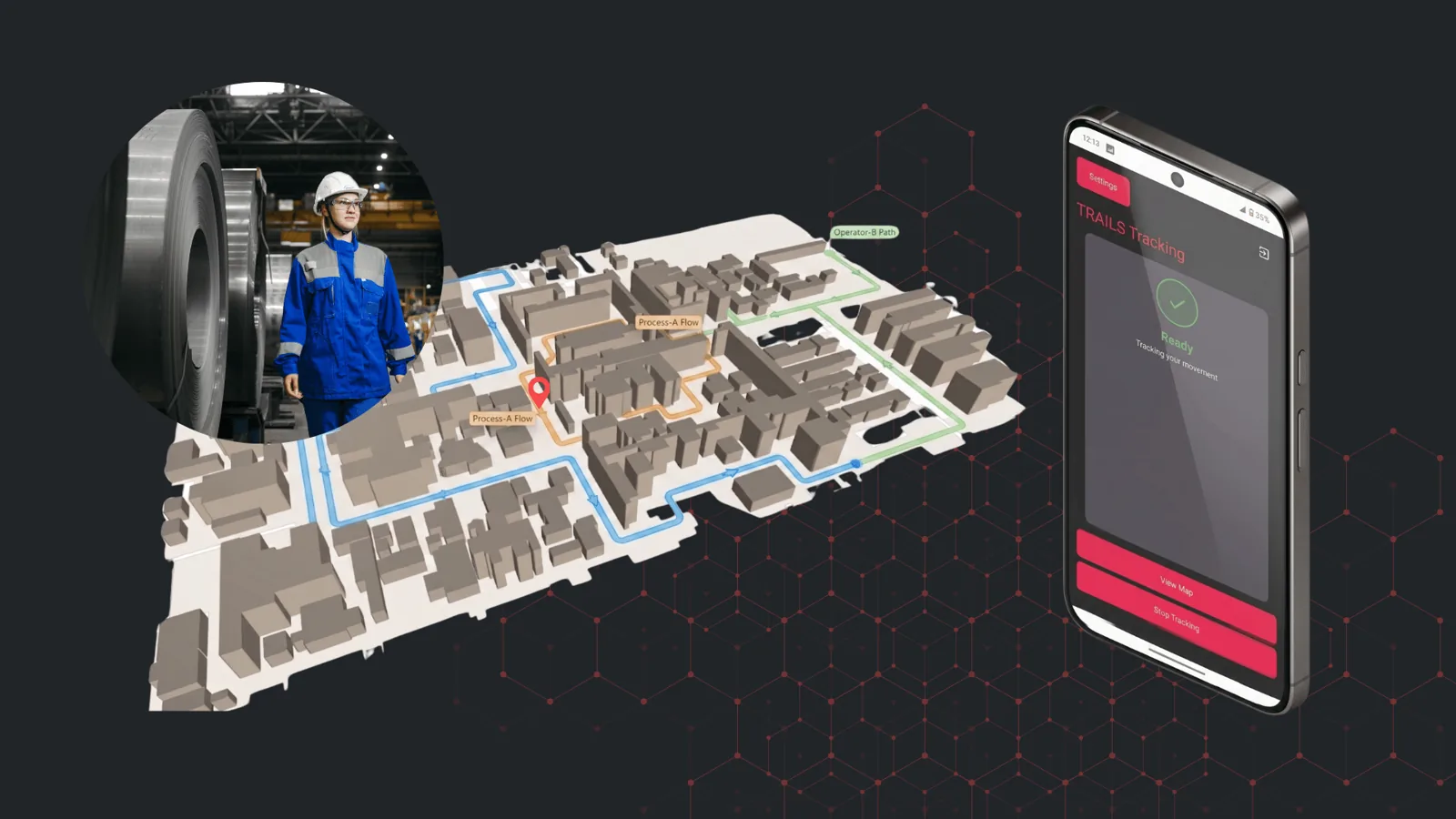
Illustration of indoor positioning with the spatial AI “TRAILS”
Key Features
- No additional infrastructure: No anchors to procure, no ceiling installation, no power wiring and no prior site survey. Deployment costs are about one-tenth of conventional systems.
- Accuracy that surpasses state-of-the-art methods: On Zeteoh’s own real-world dataset, compared with 16 published inertial odometry methods under identical conditions, TRAILS achieved the lowest absolute trajectory error (ATE), at 2.69 m. This is a 34% error reduction versus the baseline method (RoNIN-ResNet).
- Works from day one in unseen buildings: Accuracy remains nearly unchanged on data not used for training, so it can be deployed without per-building pre-training.
- Stable across device models: Average heading error is 4.5–4.7 degrees, less than one-tenth of Android’s standard orientation estimation (an average of 55–86 degrees).
- Third-party validated: In a trial with Central Japan Railway Company (JR Central), TRAILS continuously maintained an error within 3 m inside a Shinkansen bullet train running at up to 285 km/h (announced in June 2026).
- Patent granted: Zeteoh has received a patent decision in Japan through the Super Accelerated Examination program for its combination of sensor fusion and an edge-model architecture that suppresses drift without external anchors (applications planned in Europe and the United States).
Expected applications include flow-line analysis, safety management and asset tracking in factories, logistics warehouses, construction sites and infrastructure facilities. Zeteoh is currently in discussions toward deployment with customers across multiple industries.
Comment from the CEO
Yann Le Guilly, Representative Director, CEO, Zeteoh, Inc.
“We are deeply honored that the judges recognized our work on a challenge that has long been hard to see: not knowing where people are indoors. TRAILS was born from a simple question: what if we knew where people were inside buildings? Because it needs no infrastructure in the building, only smartphones or wearable devices with an IMU, we believe we can bring indoor positioning to the many sites that have been held back by cost. Encouraged by this award, we will continue to bring this technology into real-world use to help make the work of people on site safer and more efficient.”
CEATEC 2026 Exhibition
At its booth, Zeteoh will present TRAILS demonstrations and unveil a prototype of “Astra,” a spatial AI camera currently in development.
- TRAILS demonstration: A video shows TRAILS tracking positions inside an office. Visitors can also use smartphones provided by Zeteoh to see how the sensors capture movement.
- Spatial AI camera “Astra” (prototype debut): A body-camera-style wearable device with a built-in IMU, barometer, camera and compact computer. It determines the wearer’s position with TRAILS technology and records video alongside it, capturing not only “where they went” but also “what was happening there.”
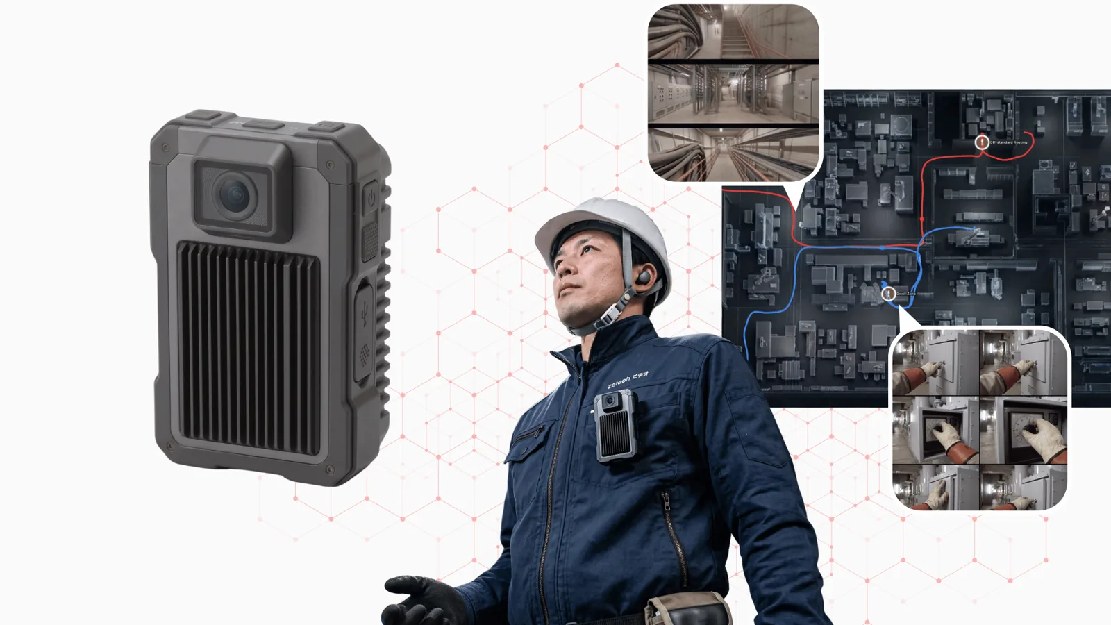
Usage illustration of the spatial AI camera “Astra” (prototype)
Exhibition Details
| Item | Details |
|---|---|
| Dates | October 13 (Tue) – 16 (Fri), 2026, 10:00–17:00 |
| Venue | Makuhari Messe (2-1 Nakase, Mihama-ku, Chiba, Japan) |
| Booth | 4H242 |